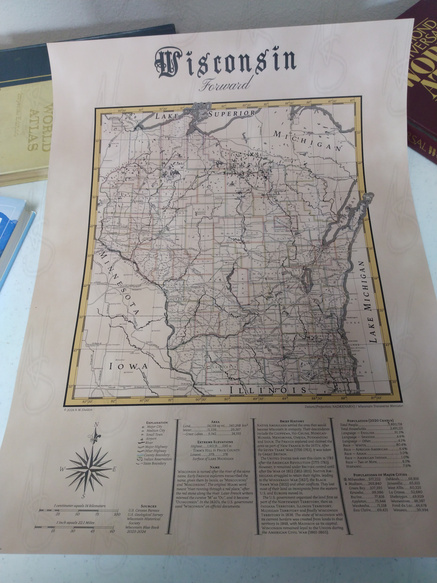
18th-century Inspired Map of Wisconsin
Published: 2024-09-17

I’ve started an Etsy shop, and I’m selling maps I’ve made myself. My first major product is an 18th-century Inspired Map of Wisconsin. Check it out, and read below to hear the story.
A few years ago, not long after I started this blog, I wandered into a craft and antiques store. I don’t remember where it was. It was the kind of shop that was divided into sections, with products from different sellers all in one building. I usually don’t go into those shops, but I think I was passing time waiting for Amy to finish somewhere else. So, I thought I’d have a look.
The shop was a maze, products stacked from floor to ceiling. Crochet dolls laid out in piles on tables. Wood-carved signs that said “Live Laugh Love” hanging on the dividers. Old toys in glass cases that reminded me of my youth. A stand of hand-bound blank books that made me feel guilty for not keeping a journal.
But what surprised me was when I turned the corner and saw a display of maps. Nice-looking maps. World, nation, state and even a few cities. Some of the maps were on metal, and came with magnets so you could plot the places you’ve been. But others were neatly framed posters, no different than the custom band and movie posters a few sections down in the store. And they weren’t antiques, they were custom made. This wasn’t the first time I’d seen maps for sale at something like this, but the first time I had the thought that, “I could make that.”
A lot happened in between then and now. But I began to notice these things elsewhere, people selling maps they made, at festivals, farmers markets, and on the internet. The idea of making my own maps and selling them at the same kind of places slowly wormed its way into my brain. Then, sometime early this year it hit the right place in my mind to push me into action. I began working on some maps I could sell.
And today, I’m finishing that first step. I’ve created a poster map, it’s nothing complicated. It’s just a map of Wisconsin, my adopted home state, with roads and cities and rivers and hills. As my artistic skills lack practice, I decided to copy the style of other maps, keeping it old-school to avoid copyright issues, but use modern data. In particular, I chose one from the 18th century because Wikipedia and the Library of Congress both have full-size scans I could download to my computer to examine.
The Mitchell Map was a map of colonial North America created by one John Mitchell in 1755 for the British Government. It was so well-known at the time that there happened to be a copy of it lying around in Paris when the diplomats met to resolve the boundaries after the American Revolution. Unfortunately, Mitchell lacked knowledge of the land past the Appalachians, and the resulting United States border was inaccurate in some parts and in other parts physically impossible.
My map of Wisconsin is drawn in a style reminiscent of the Mitchell Map, but using digital tools because hand-engraving copper plates would be expensive and exhausting even if my hands were steady enough. The boundaries are much more accurate, being based off of data from the US Geological Survey and the US Census Bureau. I guarantee my map will not lead to any international crises.
The Mitchell Map was also known for its heavy use of textual notes. To honor this part of the style, the bottom of the map is full of text and tables with geographic and historic information about Wisconsin. This map is designed to look nice on the wall, but I feel like you could stare at this every day for a year and learn something new each time.
I hope you take a look, and if you’re in need of something to decorate that one empty spot on a wall somewhere, you consider purchasing a copy. If not, perhaps you know someone who would like it, and you would be so kind as to mention this to them.
